Gino's Lace
“Epic Experience: Climb the Highest Peak in the Province of Como – Pizzo di Gino Awaits You!”
Route characteristics:
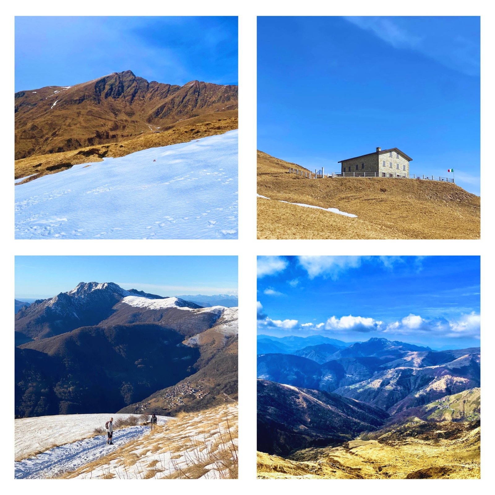
Trekking to the Summit of the Gino's Lace, also known as Meno, offers an immersive experience, enriched by elements naturalistic e historians. Crossing a varied and suggestive environment, which goes from landscapes Typically pre-Alpine to the harsh Alpine mountains, visitors immerse themselves in a unique fusion of natural beauty and military history.
The route includes woods, alpine pastures e trenches of the Great War, offering a rich and diverse experience. From well-marked paths at times more challenging and uneven, especially in the vicinity of the fortifications of the Cadorna Line and towards the summit, the terrain varies significantly. Stable stretches alternate with rocks, with some exposed sections which require special attention.
The difficulty of the excursion is rated as EE (experienced hikers), requiring a considerable physical effort and a certain experience when walking on high mountain paths. The presence of exposed passages and more challenging sections adds further challenges to the experience. winter, with the ground snowy o frozen, the excursion becomes even more challenging and potentially dangerous, requiring adequate equipment e clothing, including ice crampons and ice axe.
Along the way, walkers can find shelter e refreshment at the Croce di Campo Refuge, and buy dairy products from the’Alpe Vacchera Square during the summer season. The fortifications from the Cadorna Line They offer an interesting opportunity to explore the military history of the area.
Technical data sheet:
- Difficulty level: Expert Hiking (EE)
- Physical commitment: *****
- Distance: 7 km
- Travel time: 3:30 hours
- Difference in altitude: 1000 m
- Departure: Locality Tecchio, San Nazzaro
- I arrive: Pizzo di Gino summit 2245 m above sea level.
Route description:
From the parking location to Tecchio (1300m), the excursion begins by continuing along the service road towards the mountain pasture of Vacchera Square and of the Croce di Campo Refuge. The route begins on asphalt, then continues on a dirt road, with a moderate upward slope.
At an altitude of 1700 metres, there is the option of a short detour to the right to reach the Croce di Campo Refuge; otherwise, continuing straight, you arrive at a flat stretch near the’Alp of Piazza Vacchera (1780m). Once past the mountain pasture, leave the main road and continue straight along a path. After crossing a small valley, you reach the section of path known as "“of the trenches“, which, heading west, leads close to the military buildings of the Cadorna Line. From here, turn right onto a steep path which, through a series of hairpin bends, leads to the grassy ridge (1980m).
Along the ridge, we continue on a marked trail in white and red, gaining about 100 meters in altitude. From this point, the slope leading to the’forepeak of the Protection payment. The path zigzags up the slope, with reports in the form of red marks on the rocks, being careful not to get too close to the exposed slope to the north. From the forepeak to the summit, you walk about thirty meters along a trace which follows the crest thread. This section does not present any particular difficulties, but requires caution given the exposure on steep slopes both on the southern and northern sides. A large open space finally hosts the summit cross of the Gino's Lace, at an altitude of 2245 metres.
Images of the Route